
Great Gransden to Waresley
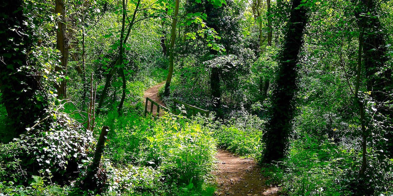
Lose yourself in magical and ancient woods. Over 500 species of moths and butterflies have been recorded. In late spring the floor of the wood is covered in bluebells and other wild flowers. Whatever the season, there's always something new to see.
Wander through a pretty hamlet. Take refreshments in an attractive garden centre cafe/restaurant, lounging on the patio or in the conservatory. Or try a peaceful pub garden. Return to the start along the quaintly named Dick and Doll Lane.

This 5 mile (11,000 steps) walk takes you through woods and along field edges and lanes. Gransden and Waresley Woods are both ancient and full of wildlife, flowers and fungi and a Site of Special Scientific Interest. You can download the Waresley and Gransden Wood Guide. Waresley is an attractive village. Waresley Park Garden Centre has a pleasant cafe/restaurant with patio and conservatory seating. Good news the Duncombe Arms is open again. They have a lovely pub garden. In winter the area around the woods may be muddy. The route is shown below on the Ordnance Survey map. You can also zoom in on a satellite view of the walk at Google Maps.

Wander through a pretty hamlet. Take refreshments in an attractive garden centre cafe/restaurant, lounging on the patio or in the conservatory. Or try a peaceful pub garden. Return to the start along the quaintly named Dick and Doll Lane.
This 5 mile (11,000 steps) walk takes you through woods and along field edges and lanes. Gransden and Waresley Woods are both ancient and full of wildlife, flowers and fungi and a Site of Special Scientific Interest. You can download the Waresley and Gransden Wood Guide. Waresley is an attractive village. Waresley Park Garden Centre has a pleasant cafe/restaurant with patio and conservatory seating. Good news the Duncombe Arms is open again. They have a lovely pub garden. In winter the area around the woods may be muddy. The route is shown below on the Ordnance Survey map. You can also zoom in on a satellite view of the walk at Google Maps.
Starting point
Park in Great Gransden along the B1046, Little Gransden Lane, just after you've past the left hand turn off to the village church. Walk up the lane beside the pink cottage called Jakins. After 250 yards, just before you reach some farm buildings, take the footpath heading off to the right.
The route takes you around the edge of a field named Squirrel Grove. You pass through the field hedge to reach Gransden Wood. Walk along the edge of the wood for just over 400 yards to reach the reserve entrance. Don't be tempted to enter the wood before this point. The top half of the wood is privately owned, so there is no public access.
The route takes you around the edge of a field named Squirrel Grove. You pass through the field hedge to reach Gransden Wood. Walk along the edge of the wood for just over 400 yards to reach the reserve entrance. Don't be tempted to enter the wood before this point. The top half of the wood is privately owned, so there is no public access.
Point 1
Head into the heart of the woods. Existing for thousands of years, they are a magical place. With many paths to choose from it's easy to lose your way, so take a copy of the Wood Guide with you. You should aim to exit at the south west corner of the wood.

Point 2
Turn left and after just over 100 yards along the wood edge follow the track right and away from the wood. The path turns left after 500 yards, then right after a further 150 yards, to cross through Wood Farm, a major producer of free range eggs.
Passing through a farm gate, you come to the bottom of Vicarage Road. As you approach the centre of Waresley there are some attractive buildings.
Passing through a farm gate, you come to the bottom of Vicarage Road. As you approach the centre of Waresley there are some attractive buildings.
Point 3
From the top of Vicarage Road your first choice for a break is at the Duncombe Arms. Another option is to turn left, and just under 200 yards cross the road to Waresley Park Garden Centre. You'll find an attractive cafe/restaurant with patio and conservatory seating. The garden centre has one of the areas best displays of Xmas lights and decorations during November and December.
To continue the walk retrace your steps through Wood Farm.
Point 4
Rather than following the path left to head back towards Waresley Wood, continue straight on along the bridleway. This skirts the bottom of the field south of Waresley Wood. As you get parallel to the bottom righthand corner of the wood the track turns left. After 450 yards you reach Waresley Wood. Follow the track along the edge of the wood for just under 500 yards.
Point 5
The route continues straight on along a path called Dick and Dolls Lane. Half a mile brings you back to the B1046 Little Gransden Lane and the start of the walk.
Click the 'Print Friendly' button below to print out this walk to take with you. Or for more walks click the 'Return Home' button at the foot of this page. Did you enjoy the walk? Notice anything unusual? Why not add a comment below to tell fellow amblers what you liked about it?
Top tearooms and related walks
Regular readers of Cambridgeshire Walks will know a strategic snack somewhere along the route is a must. If not packing a picnic, an attractive tearoom makes any walk all the more enjoyable. So here are Cambridgeshire Walks favourite stopping off spots. Even better, below each are links to walks that take you right to them.
Houghton Mill Tearoom

Outdoor seating with a view overlooking the mill pond. The cream tea is delicious. There's even a savoury version, with cheese scone, mascarpone and onion jam. All scones are cooked on the premises and fresh. Try any of the following walks.
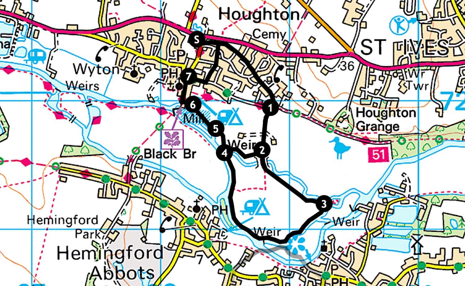
Houghton Meadows and the River Great Ouse (3 miles, 6,600 steps)
Houghton to Godmanchester Nature Reserve (4 miles, 8,800 steps)
St Ives to Houghton via Wyton on the Hill (6 miles, 13,200 steps)
St Ives to Hemingford Abbots (6 miles, 13,200 steps)
Houghton to Godmanchester (7 miles, 15,400 steps)

The shop is located in a 19th century former toll house that has been very stylishly renovated. Also seats outside to watch the world go by. Great range and quality of cakes, snacks and coffee, all at reasonable prices. The paninis are delicious, savoury quiches a meal in themselves. Try any of the following walks.
Hemingford Meadow (2 miles, 4,400 steps)
Wilhorn Meadow to the Guided Busway (3 miles, 6.600 steps)
The Willows Cafe

The warm cheese scone with chutney and butter is a meal in itself. Great home made sausage rolls. Wide range of delicious cakes. The garden is particularly nice and cosy to sit in. Try any of the following walks.
The warm cheese scone with chutney and butter is a meal in itself. Great home made sausage rolls. Wide range of delicious cakes. The garden is particularly nice and cosy to sit in. Try any of the following walks.
Brampton Wood (up to 3 miles, 6,600 steps)
Brampton Circular Walk (4 miles, 8,800 steps) (Note comment at bottom of this walk)
Monks Wood
This amble is just a short introduction to a little known local gem. So there's a good chance you'll have this ancient woodland all to yourself to feel at one with nature. One thing is certain, you'll soon be back to explore more of the paths and get deeper into the wood. With a history stretching back more than 1,000 years, it's a rare visit when you don't come away having spotted something different. Pack a picnic to rest half-way in East Field.
It's a National Nature Reserve and one of the country's top sites for beetles; there are more than 1,000 species. Throw in a wide range of woodland plants, butterflies, birds and other wildlife. The wood has been studied in depth by the experimental research station located here for over forty years from 1963. If you really want to dive into the detail of Monks Wood, read the report ENRR613 Main.

This 2 mile (4,400 steps) walk can be varied by taking alternative routes shown in the map below. Generally easy walking. Beautiful autumn tints as shown in the image above. Stunning bluebells in late spring as shown in the image after Point 1. Can be muddy during wet weather or in winter. May find yourself tackling fallen branches or uneven ground on some of the narrower paths. Good idea to take a copy of the map to find your way back to the start. You can also zoom in on a satellite view of the walk at Google Maps.

Starting point
There are spaces for a couple of parked cars to at the junction of the B1090 and Bridge Street, the road leading to Woodwalton. Although not a formal car park, parking is allowed so long as you don't block access. Other parking areas are shown on the map.
Follow the track leading away from the junction. After 200 yards you'll reach the entrance to the wood and an information board. Turn left and walk up a slight incline along the edge of the wood. After just over 400 yards, as the route turns slightly to the left, take the path on the right called Owl Ride, heading into the wood. Follow this for about 350 yards.
Point 1
At the end of Owl Ride you'll come out at the top of one of the broad avenues, called Stocking Close Ride. The route heads downwards. If you have children with you, part of the decline is gently steep enough for a race. After 500 yards Stocking Close Ride intersects Main Ride, the broadest route through the wood. Turn left and follow Main Ride for 350 yards.

Point 2
Hotel Ride crosses Main Ride. Turn right and follow Hotel Ride for 450 yards. Turn right into Eastfield Ride. It's worth having a detour into East Field, a grassy area with a wildlife pond. A perfect spot for a picnic.
Follow Eastfield Ride for 600 yards.
Point 3
At the end of Eastfield Ride you'll find yourself at the northernmost tip of the wood and quite close to the B1090. Follow the path around to the right into Eastedge Ride. After 500 yards you'll find yourself at the beginning of Main Ride. Continue straight on to return to the wood entrance and the track back to your car.
Click the 'Print Friendly' button below to print out this walk to take with you. Or for more walks click the 'Return Home' button at the foot of this page. Did you enjoy the walk? Notice anything unusual? Why not add a comment below to tell fellow amblers what you liked about it?
Thanks to Martyn Ferry for image 1.
Somersham Nature Reserve and Lake
A perfect short walk for a Sunday morning or weekday evening. Amble through a pleasant village to view evidence of its railway heritage. Pass through woodland and meadow. Pack a picnic and sit on one of the benches overlooking the peaceful lake. Or visit a lovely new tea room.
Designated as a County Wildlife Site, look for grass snakes and common lizards sunning themselves along the old railway line. The meadows are full of butterflies, dragonflies and bees. Watch out for brimstone and common blue butterflies. Herons and great crested grebes inhabit the lake. You might even catch the flash of a kingfisher. In autumn the woodland areas are a palette of colours.

This two and a three-quarter mile (6,100 steps) walk passes through village, woodland and meadows. Plenty of benches to picnic beside the lake. Can be muddy through the wooded areas in winter. The route is shown below on the Ordnance Survey map. You can also zoom in on a satellite view of the walk at Google Maps. Why not review details of Somersham's listed buildings before your walk?

Starting point
There is a free car park in Church Street, roughly opposite the church.
Somersham is an Anglo-Saxon settlement. The Bishop's Palace, located at the far end of Church Street, was a grand location visited by both King Richard (Richard the Lionheart) and King John around 1200. There are few historical buildings left in the village after a series of fires in the 19th century.
Walk out of the car park and turn right into Church Street, and right again at The Cross into the High Street. After 500 yards carry straight on into Station Approach, keeping to the left-hand side rather than walking along the road.
Point 1
Take the footpath on the left, a few yards past the last house.
Look to your left for a short stretch of railway track, the only evidence of the railway that ran from Somersham to Chatteris. You are walking where Somersham railway station was once situated. It still exists, having been re-erected at Fawley Railway Museum. Hard to believe that for a time it was very busy, with 80 trains a day passing through. Also used as a diversionary line when there was a problem with the main route, the Flying Scotsman occasionally passed through Somersham.

Point 2
After just over 200 yards take the path to the right. The route gradually arcs to the left and then straightens out passing through light woodland as shown above. Follow the path for a third of a mile through the woods as it skirts a meadow. After a right and left turn, the track turns left and drops down into the top of the meadow.
Follow the route as it crosses the top of the meadow and exits.
Point 3
Turn left to walk down what was once the Great Northern and Great Eastern Joint Railway line to Chatteris.
Point 4
After a quarter of a mile take a path to the right and keep right to walk around the lake, created as a result of gravel extraction for use in railway construction. There are several benches positioned to look over the peaceful scene, as shown below. A perfect spot for a picnic.
Continue to walk around the lake.

Point 5
Exit the lake area and walk back onto the old railway track. Turn right to and retrace your steps into Station Approach and then to the High Street.
Point 6
After just over 100 yards, turn left along Colne Road. Another 50 yards and you'll see Galley's Drove on your right.
If you're ready for some refreshments, it's a good time to visit Annabelle's Cakes, a further 250 yards on the right along Colne Road, in Cranbrook Plants. See the red T on the map. It features some interesting cakes. Also a chance to wander around the garden centre, and an interesting corner with odd bits & bobs to buy at reasonable prices.
To continue the walk, head down Galley's Drove.
 Point 7
At the end you enter a field. Follow the footpath diagonally across the fieldfield. At the field edge you'll find a stream on your right. At the far corner of the field take the footbridge on the right and follow the footpath along the left edge of common land.
Point 8
You'll reach a stile beside a house. After passing through, turn left and 150 yards brings you back to Church Street. Another 200 yards and you're back to the start point.
Point 6
After just over 100 yards, turn left along Colne Road. Another 50 yards and you'll see Galley's Drove on your right.
If you're ready for some refreshments, it's a good time to visit Annabelle's Cakes, a further 250 yards on the right along Colne Road, in Cranbrook Plants. See the red T on the map. It features some interesting cakes. Also a chance to wander around the garden centre, and an interesting corner with odd bits & bobs to buy at reasonable prices.
To continue the walk, head down Galley's Drove.
At the end you enter a field. Follow the footpath diagonally across the fieldfield. At the field edge you'll find a stream on your right. At the far corner of the field take the footbridge on the right and follow the footpath along the left edge of common land.
Point 8
You'll reach a stile beside a house. After passing through, turn left and 150 yards brings you back to Church Street. Another 200 yards and you're back to the start point.
Click the Print Friendly button below to print out this walk to take with you. Or for more walks click the 'Return Home' button at the foot of this page. Did you enjoy the walk? Notice anything unusual? Why not add comment below to tell fellow ramblers what you liked about it?
THE THICKET FOOTPATH - A victory for common sense

Following the public enquiry, the inspector's report refusing Cambridgeshire County Council (CCC) the right to make The Thicket footpath a cycle track seemed a somewhat hollow victory. Her conclusion was she could find no reason why the route could not be shared. The primary reason for refusal was lack of any risk assessment or impact analysis. In fact, her comments guided CCC for a better attempt next time.
In preparation for what seemed the inevitable, Cambridgeshire Walks submitted a Freedom of Information Request for the following :
- Details of all costs incurred to date or outstanding regarding this order.
- Following the Secretary of State's decision letter to Mr Ouditt dated 10 May 2017, does Cambridgeshire County Council intend to take further steps to implement the order?
- If the answer to 2. above is 'Yes', what are the details of costs budgeted for these further steps?
The FOI response received is revealing. Somewhat annoying CCC spent £5,640 employing Mr Cain Ormondroyd, barrister, for the two day enquiry to give objectors a hard time. More importantly, it confirms CCC have given up on converting The Thicket footpath into a cycle track. A victory for common sense indeed!
To read the original post alert of the change with readers comments, and links to CCC's order and the enquiry experience, click here.
The Thicket Path Enquiry - The Result

It's the best part of two months since the Enquiry into Cambridgeshire County Council's attempt to turn The Thicket footpath into a cycle track. The Secretary of State's decision has just been made. The County Council's Order has been turned down. There are links to the Secretary of State's decision letter and the Inspectors' report at the bottom of this article.
However, it may be a short-lived victory for walkers, joggers, wheelchair users and considerate cyclists. The Inspector's report concludes:
"There is a strong case for the designation of an off-road route between Houghton and St Ives that would provide a convenient facility for commuter journeys by bicycle, leisure cycling and as part of the NCN Route 51. The Thicket Path is the most obvious candidate. In effect, this footpath has already been converted in as much as the surface has been upgraded and it is currently promoted in many places as a cycle route.
It is my conclusion that the absence of sufficient information about current and anticipated use, and users, of the Order route, and the uncertainty over the range of lawful user groups, leaves the question over the adequacy of its width unanswerable at the present time and that therefore it is premature to confirm this Order, despite the length of time that has passed since it was made. That is not to accept that to ‘do nothing at all’ is the solution here but simply that a cycle track has not been shown to be justified on the facts currently available."
In effect, the Inspector agrees with the County Council that an off-road cycle track between St Ives and Houghton is desirable and The Thicket footpath is the most suitable route. It appears the only reason she did not authorise the change was the Council's lack of risk analysis and impact assessment.
Having employed a barrister costing several hundred pounds an hour to argue their case at the Enquiry, will Cambridgeshire County Council now spend more taxpayers' money pursuing the change? A Freedom of Information request has been submitted to the Council asking for the following details:
- Details of the costs so far incurred or yet to pay in pursuance of Cambridgeshire County Council's Order.
- Following the Secretary of State's refusal to confirm letter to Mr Ouditt, does the Council intend to further pursue this Order?
- If the answer to 2. above is 'Yes', what is the detailed breakdown of future costs the Council anticipates incurring in pursuing this Order?
Click any of the following links for more information:
Previous articles on this topic under The Walking Blog
The Thicket & Houghton Meadows
An Amazon jungle on the edge of St Ives. Sounds unlikely? Not if you know about The Thicket. Amazingly bright green in spring and early summer and full of birdsong. Follow on with a walk through medieval ridge and furrow meadows bursting with wildflowers so rare, they've been designated a Site of Special Scientific Interest.
Walk through avenues of trees to an ancient woodland. Pass the site of kilns used to make bricks for the New Bridges causeway. Look out for muntjac deer, green woodpeckers and jays. Bursting with wild flowers, have some target practice with the plant that caused the invention of Velcro. Look out for a wide variety of moths, butterflies and dragonflies.
Walk through avenues of trees to an ancient woodland. Pass the site of kilns used to make bricks for the New Bridges causeway. Look out for muntjac deer, green woodpeckers and jays. Bursting with wild flowers, have some target practice with the plant that caused the invention of Velcro. Look out for a wide variety of moths, butterflies and dragonflies.
There are a couple of articles you might like to view to enrich your walk before setting off, both by landscape historian Keith Grimwade. Click either The How Brickworks, Berman Park, or Thicket Path - 1,000 Years of Landscape History.
This green walk of just over 2 miles (5,000 steps) is along a riverside footpath to climb a track through woodland, through a stile and into an open field. Follow with an amble through ancient and unspoilt meadows. Tranquil places to sit, rest and have a picnic. Very high count of wild flowers, insects and birdlife. Does involve some inclines and a stile to climb over. In winter or after heavy rain can be muddy. Keep an eye out for speeding cyclists silently approaching from behind along The Thicket path. The route is shown below on the Ordnance Survey map. You can also zoom in on a satellite view of the walk at Google Maps.

Starting point
If you've brought the car, park for free in the St Ivo Indoor Sports Centre car park. Walk away from the car park, back into Westwood Road and the direction you entered. At the tight right and left bend take the path leading into Berman Park. Follow the path to the opposite corner of the park to access the Thicket Path. Check there are no speeding cyclists. Be particularly careful if accompanied by children.
Point 1
This section of the walk is very pleasant, lined with trees that meet overhead as shown below.
The field on your left is Nobles Field, where the St Ives Regatta is periodically held. Bought by the Town Council from the Noble family, who originally farmed this area, it is used to benefit the people of St Ives. If you're in no hurry, you can walk around the perimeter of the field and along the edge of the Great Ouse, to return to The Thicket path at the far end.

Point 2
This section of the walk is very pleasant, lined with trees that meet overhead as shown below.
The field on your left is Nobles Field, where the St Ives Regatta is periodically held. Bought by the Town Council from the Noble family, who originally farmed this area, it is used to benefit the people of St Ives. If you're in no hurry, you can walk around the perimeter of the field and along the edge of the Great Ouse, to return to The Thicket path at the far end.
Point 2
Along the path and on your right you'll pass several areas of vaguely semicircular land set back a few yards from the path edge. These are the sites of brick kilns, where over one million bricks were made for the New Bridges causeway that leads away from St Ives bridge. Clay was dug from the surrounding land, made into bricks and loaded onto lighters to be floated down to the wharf by The Dolphin Hotel.
A few yards further and there are open views across Hemingford Meadow. This is one of the few spots exposed directly to river access and the site of an unfortunate tragedy which gained much attention in St Ives as reported in the Hunts Post of 19 February 1915.
Point 3
After about 500 yards you pass a bench on your left and walk through three bollards. Just after this, on your right, is the information board for The Thicket. Turn right and walk up the path. To access a map and information about The Thicket, click here.
Follow the track up a hill before turning left and winding through an ancient woodland full of wild plants, moths, butterflies and dragonflies The tree canopy echoes with birdsong. If you tread silently round each corner you may disturb a muntjac deer There's a good chance of hearing the laugh of a green woodpecker or the flash of a jay in flight.
The route is lined with many burdocks. The plant is more commonly known for the use of its roots in the mediaeval drink dandelion and burdock (today's fizzy sugar version is unlikely to contain any plant extracts). Also great fun to pick the burrs and use a friend as target practice. Their ability to stick to just about any cloth surface was the inspiration behind Swiss engineer George De Mestral's invention of Velcro in the 1940s.

Point 4
After 400 yards the track heads left, back down the hill to the main path. Turn right instead and walk up the incline. Turn left after a few yards to cross a footbridge and pass through a stile.
You reach an ancient meadow as shown above. At the top of the hill evidence has been found of a Roman fort. The grassy mounds are the homes of yellow meadow ants. With it's south facing aspect catching the sunshine, this is a great place to have a picnic, although you are asked to stay near the footpath since the field is private land.
After just under 200 yards the path turns left to head down the hill. At the bottom there's a stile to climb over.
Point 5
You're now back on The Thicket path. Turn right and walk for 100 yards to reach the entrance to Houghton Meadows on your left. The Meadows, pictured below in May with early purple orchids and buttercups, are a rare example of ancient grassland designated a Site of Special Scientific Interest because of both their botanical and historical interest.
Stunning in late spring and early summer, the three meadows are full of insects and wild flowers. You'll also see purple great burnet, yellow rattle, white meadowsweet, lemon cowslips and violet-blue meadow cranesbill. The star of the show is the green winged orchid, nationally scarce. More common but no less attractive is wedgewood blue veronica. On a warm day tread carefully and you might catch a grass snake sunning itself along the meadow's edge. Also worth noting are the archaeological ridge and furrow patterns of agriculture, evidence of ploughing by oxen up to the 1600s.
To walk around the meadows, follow the track to the right across the top corner of Grove Close, around the back of a copse. Walk into Far Close and turn left to walk down the lefthand side. At the bottom turn left, back into Grove Close. Follow the path along the bottom, up the far side and along the top of the close to return to the entrance.
Back on The Thicket path, turn right to head back towards St Ives.

Point 6
After 300 yards you reach The Thicket again. On the return route, follow the main path. You pass through an avenue of green, full of bird song. Although more likely seen at dusk, keep a watch on either side for a fleeting glance of deer, foxes or voles.
A further 600 yards and you're back at the three bollards described in Point 3. Follow the route back to the start point at sports centre car park. Feeling peckish? Pop into the Zest Cafe at the leisure centre for very reasonably priced food and drinks.
Click the 'Print Friendly' button below to print out this walk to take with you. Or for more walks click the 'Return Home' button at the foot of this page. Did you enjoy the walk? Notice anything unusual? Why not add a comment below to tell fellow amblers what you liked about it?
A few yards further and there are open views across Hemingford Meadow. This is one of the few spots exposed directly to river access and the site of an unfortunate tragedy which gained much attention in St Ives as reported in the Hunts Post of 19 February 1915.
Point 3
After about 500 yards you pass a bench on your left and walk through three bollards. Just after this, on your right, is the information board for The Thicket. Turn right and walk up the path. To access a map and information about The Thicket, click here.
Follow the track up a hill before turning left and winding through an ancient woodland full of wild plants, moths, butterflies and dragonflies The tree canopy echoes with birdsong. If you tread silently round each corner you may disturb a muntjac deer There's a good chance of hearing the laugh of a green woodpecker or the flash of a jay in flight.
The route is lined with many burdocks. The plant is more commonly known for the use of its roots in the mediaeval drink dandelion and burdock (today's fizzy sugar version is unlikely to contain any plant extracts). Also great fun to pick the burrs and use a friend as target practice. Their ability to stick to just about any cloth surface was the inspiration behind Swiss engineer George De Mestral's invention of Velcro in the 1940s.
Point 4
After 400 yards the track heads left, back down the hill to the main path. Turn right instead and walk up the incline. Turn left after a few yards to cross a footbridge and pass through a stile.
You reach an ancient meadow as shown above. At the top of the hill evidence has been found of a Roman fort. The grassy mounds are the homes of yellow meadow ants. With it's south facing aspect catching the sunshine, this is a great place to have a picnic, although you are asked to stay near the footpath since the field is private land.
After just under 200 yards the path turns left to head down the hill. At the bottom there's a stile to climb over.
Point 5
You're now back on The Thicket path. Turn right and walk for 100 yards to reach the entrance to Houghton Meadows on your left. The Meadows, pictured below in May with early purple orchids and buttercups, are a rare example of ancient grassland designated a Site of Special Scientific Interest because of both their botanical and historical interest.
Stunning in late spring and early summer, the three meadows are full of insects and wild flowers. You'll also see purple great burnet, yellow rattle, white meadowsweet, lemon cowslips and violet-blue meadow cranesbill. The star of the show is the green winged orchid, nationally scarce. More common but no less attractive is wedgewood blue veronica. On a warm day tread carefully and you might catch a grass snake sunning itself along the meadow's edge. Also worth noting are the archaeological ridge and furrow patterns of agriculture, evidence of ploughing by oxen up to the 1600s.
To walk around the meadows, follow the track to the right across the top corner of Grove Close, around the back of a copse. Walk into Far Close and turn left to walk down the lefthand side. At the bottom turn left, back into Grove Close. Follow the path along the bottom, up the far side and along the top of the close to return to the entrance.
Back on The Thicket path, turn right to head back towards St Ives.
Point 6
After 300 yards you reach The Thicket again. On the return route, follow the main path. You pass through an avenue of green, full of bird song. Although more likely seen at dusk, keep a watch on either side for a fleeting glance of deer, foxes or voles.
A further 600 yards and you're back at the three bollards described in Point 3. Follow the route back to the start point at sports centre car park. Feeling peckish? Pop into the Zest Cafe at the leisure centre for very reasonably priced food and drinks.
Click the 'Print Friendly' button below to print out this walk to take with you. Or for more walks click the 'Return Home' button at the foot of this page. Did you enjoy the walk? Notice anything unusual? Why not add a comment below to tell fellow amblers what you liked about it?
Coconut oil : Health or Hype?

BBC's health programme 'Trust me I'm a Doctor' is looking for 100 volunteers in our area. They want to find out if cooking with coconut oil really is all it's cracked up to be. So for four weeks volunteers will include a different cooking oil in their diet, either coconut, butter or olive.
Volunteers need to be between 50 and 75 years of age and not had any major medical conditions or be taking medication. You also need to be available between May and August 2017. Want to give it a go? Just complete the short application form.
Walking blog
Open Gardens in Cambridgeshire
It's no secret Cambridgeshire Walks likes an amble around an attractive village. Throw in a few pleasant surprises and some food and drink and you've got the perfect recipe for a wonderful day out. That's where Open Garden events comes in. Stunning gardens, some of them jaw-droppingly beautiful. Great ideas to consider. Lots of homemade food and plants to buy. And really enthusiastic owners. One owner even bagged up some unusual seeds to take away.
It's no secret Cambridgeshire Walks likes an amble around an attractive village. Throw in a few pleasant surprises and some food and drink and you've got the perfect recipe for a wonderful day out. That's where Open Garden events comes in. Stunning gardens, some of them jaw-droppingly beautiful. Great ideas to consider. Lots of homemade food and plants to buy. And really enthusiastic owners. One owner even bagged up some unusual seeds to take away.

Favourite walks lists, both national and local
Time to think about a summer break. Why not try a walking holiday? Do a touring trip, stopping at various places to take in some fabulous walks. Or maybe do one really long walk over several days. Here are two lists of national and local favourite walks. No lack of choice!

The Thicket footpath. A victory for common sense!
Following the public enquiry, the inspector's report refusing Cambridgeshire County Council (CCC) the right to make The Thicket footpath a cycle track seemed a somewhat hollow victory. Her conclusion was she could find no reason why the route could not be shared. The primary reason for refusal was lack of any risk assessment or impact analysis. In fact, her comments guided CCC for a better attempt next time.
Read more...
Read more...
CARE ABOUT THE THICKET PATH? Last chance to register your view!
The Government has appointed an Inspector to decide on Cambridgeshire County Council's plan to change The Thicket footpath into a cycle track. The Council have referred the decision because they've already received a lot of opposition. Nevertheless they're pressing ahead. A Local Public Enquiry is being held at 10.00am on Wednesday 22 March and Thursday 23 March in Commemoration Hall, Huntingdon.
Read the original article & comments, the Order and plans, options to register your view or Thicket Inquiry - The Experience.

1900 OS maps being added to walks!
There's rarely a walk that doesn't involve a few minutes pondering the origin of some feature in the landscape. Take the Brampton circular walk as an example. Wander around the back of RAF Brampton and you come upon a field filled with bumps and hollows. Interesting enough in itself. But it's the pronounced hillock to the right that's always been a puzzle.

The beauty of ivy
Close your eyes and think of ivy berries in winter. What colours do you see? Bet you're way off the mark. Next time you wander along a hedge containing ivy, stop for a few minutes and look. The berries are subtly beautiful with shades of dark and mid grey, pink and coffee. Ivy can be invasive, but is a very important plant for wildlife. Ivy nectar and fruit appear when there are few equivalent food sources around.
Read more...Close your eyes and think of ivy berries in winter. What colours do you see? Bet you're way off the mark. Next time you wander along a hedge containing ivy, stop for a few minutes and look. The berries are subtly beautiful with shades of dark and mid grey, pink and coffee. Ivy can be invasive, but is a very important plant for wildlife. Ivy nectar and fruit appear when there are few equivalent food sources around.

Walking in the Jurassic
Even Cambridgeshire Walks hates muddy boots. Amble anywhere around St Ives during a wet winter and you're going to encounter sticky clay. When you do, look down with fascination rather than distaste. You may be walking through a Jurassic sea bed laid down 150 million years ago. That sea was tropical, warm and full of life. Ammonite, belemnite and devil's toenail fossils are quite common finds.
Read more...
Do you count?
As usual at this time of year, there are a couple of extra pounds going spare around the Cambridgeshire Walks' waistline. Often takes until April to get back to fighting weight. With the gift of a second hand Fitbit Charge HR, this year things have changed. Within two weeks all trim and tidy in spite of being surrounded by sweet stuff. Here's the low down on losing weight. Cambridgeshire Walks is all about gentle exercise.
Read more...
Spindle tree
Spot something exotic in a hedgerow while out walking in autumn or winter? Plants that add colour at this time of year are rare. A dash of dark pink and orange is most likely to be a native spindle tree. Wander along the Thicket Path and you'll find several examples. What attracts your attention are the seed pods. The leaves also add to the interest, turning a rich orange-red before dropping in winter. The plant is valuable to a wide range of wildlife.
Read more...Spot something exotic in a hedgerow while out walking in autumn or winter? Plants that add colour at this time of year are rare. A dash of dark pink and orange is most likely to be a native spindle tree. Wander along the Thicket Path and you'll find several examples. What attracts your attention are the seed pods. The leaves also add to the interest, turning a rich orange-red before dropping in winter. The plant is valuable to a wide range of wildlife.

Mad for maps
You've probably clocked that Cambridgeshire Walks just loves maps. There's adventure in every map. So where do they come from? Access free online Ordnance Survey maps at Footpath Maps. When out and about, do you ever spot a footpath sign heading away from the road and wonder where it leads? Check the route to see if it's worth following using this website. Pop your postcode into the search box in the top right hand corner and click go.
Read more...

All the snowmen in St Ives are lost!
Got a three-nager to occupy in December? Why not walk them around St Ives town centre, looking for snowmen? The storyline is all the snowmen in St Ives have been lost, and only your little one/s can find them. The snowmen can be found in most of the shop windows. Equally riveting from age two upwards. There are several hundred, from large single displays to lots of little ones. Best time for the expedition is after dark, with the streets lit by Christmas decorations.
Read more...
Five ways to spot if you're a dromomaniac
Do you get an uncontrollable urge to wander? Not just the standard itchy feet. We're talking serious psychological urge to get up and go. If you've got this far into reading without scooting off, you probably haven't got it. A modern example is Charles Veley, the Guinness Book of World Records most travelled man. By the age of 47 years he'd travelled two million miles and visited 95% of the locations on earth.

Go get lost!
Ever been to London and just wandered? The French have name for you... flâneur. An inquisitive ambler. And it's a wonderful thing to do. No time schedule, no route. Just idly stroll. In the process you'll discover some amazing things. Around every corner there's an adventure. The Flaneur Society have a Guide to Getting Lost. You're just an hour and the price of a rail ticket away from a wonderful adventure. What's stopping you?

Five good reasons to go for a walk
In this 24/7 world when we're busy all the time, taking an hour or more out of a busy schedule to go for a walk is just going to add to the pressure, right? Strangely enough, not. The busier you are, the more important it is for you take time out to do something which relieves stress and forces you slow down. Why pay a fortune for a gym membership and end up queuing for equipment in a sweaty room? Walking is free and doesn't need any special clothing.
Read more ...

Read more ...
Thicket Path Inquiry - The Experience

Apparently it was a full day yesterday, from 10.00am to 5.00pm. Started this morning at 9.30am, continuing with objections. Three formal organisations plus about ten in the audience present as objectors. Three on Cambridgeshire County Council's side. The Inspector as chairperson.
The County Council have employed Cain Ormondroyd, no less, to represent them. He's a top rated barrister who must be costing them several hundred pounds an hour. Somewhat galling to see the hard pressed Council spending taxpayers money to defend itself... against its taxpayers!
First up was the representative from Houghton and Wyton Parish Council. A somewhat rambling presentation lasting best part of two hours. Then an hour's grilling from the barrister. One of the Parish Council's arguments about the footpath being too narrow was somewhat flawed when they admitted they favoured the route being appointed as a bridle way. If it's not wide enough for a cycle track, surely there's no chance for a bridle track. Their rather strange justification was horses slow bicycles down.
Was next up and really looking to a verbal joust with Mr Ormondroyd. Made my points, questioned Steve Ouditt, the manager from the Council, about his non reply to my calls, voicemail and email. Apparently he never got the voicemail or email. But puzzlingly, I was on a list of people he'd emailed a reply to. Did I get that? No I didn't.
Bit of an anti-climax when Mr Ormondroyd chose not to question me. Stayed a further 30 mins to listen to the next objector, left about 1.30pm.
Not sure when the Inspector's decision will be published. I've indicated I'd like a copy and will pop it on the web site when received.
CARE ABOUT THE THICKET PATH? Last chance to register your view!
The Council have tried to suppress objections by failing to communicate the change adequately. Three small notices at either end of the footpath that for all the world look like fly posters. That's it.
The Inspector is unlikely to know much about The Thicket footpath. He won't know this is a much-loved local route used by at least ten times as many walkers and joggers as cyclists. He'll be unaware that most cyclist are solo, whereas foot traffic is often in pairs or groups. The acceptance of considerate leisure cyclists and the danger from those who speed and give no warning is unknown to him. Unless we let him know.
This is all about numbers. If insufficient people object, the change will go through. By changing the priority on the footpath, there's a significant risk this ancient route will be spoiled for walkers, joggers, motorised wheelchair users and considerate leisure cyclists. So please make your view known this weekend. It's really easy. Just choose one of the following two methods.
Vote for the petition
Just takes seconds. Support John Hunt's excellent petition to leave things as they are. Loads of comments shown. Currently he has the support of just under 500 people. Can he reach 500? Why not 1,000. Please vote for the petition.
Send your view directly to the Inspector
Even better, why not tell the Inspector exactly what you think? This would be even more powerful. The objections Cambridgeshire Walks has raised are shown below. Fell free to use any of these, even better if you think of additional points. Email concerns to nationalcasework@dft.gsi.gov.uk. Click the link and an email opens automatically including the reference NATTRAN/E/CYCLETRACK/92. For good measure you could also email your town or parish, district and county councillors.
You can read the original article with all the comments received, view the Order and plans or read about Thicket Inquiry - The Experience. Below are the objections raised by Cambridgeshire Walks.

You can read the original article with all the comments received, view the Order and plans or read about Thicket Inquiry - The Experience. Below are the objections raised by Cambridgeshire Walks.
IMPORTANT UPDATE! The plans changing The Thicket footpath into cycle track.
Notices along The Thicket footpath state Huntingdonshire District Council as one of the two locations with plans to view. Save yourself the trip. No one at HDC has a clue about the documents. Managed to get a name at Cambridgeshire County Council. Despite several calls and a voicemail left, no response.

Fortunately an email sent last week to the National Transport Casework Team is answered. Click the order and plans to view yourself. Assuming these documents dated 2014 are the right ones, they're not very helpful. Mention 'part of the width of the footpath' being designated a cycle track between 2.5 and 3 metres in width. Shows the affected part from Barnes Walk, St Ives, all the way to Meadow Lane, Houghton. Mentions the installation of three bollards, which are already in place.
An email has gone to Steve Ouditt of the Rights of Way and Access Team at Cambridgeshire County Council with the questions below.
NOTE You can read the original article and comments received, view options to register your view, or read Thicket Inquiry - The Experience.

NOTE You can read the original article and comments received, view options to register your view, or read Thicket Inquiry - The Experience.
IMPORTANT! Save The Thicket footpath!
Walked along The Thicket footpath recently? Notice some innocuous notices fixed to walls and lampposts? If you didn't, you might want to read the contents! It's proposed to create a wide cycle track along the footpath.

A good thing, you might think. Will reduce the risk to walkers by lycra louts speeding silently from behind. But it’s the width of the section for cyclists that is of concern. Between 2.5 and 3 metres. That sounds like more than half the width. Many walkers are in pairs or more. Most cyclists are single travellers. Won’t the change effectively make The Thicket footpath a cycle track?
They don't make it easy to view the plans. Huntingdonshire District Council offices in Huntingdon or Cambridgeshire County Council offices in Cambridge. There’s a Public Enquiry at 10am on Wed 22 March and Thu 23 March at Commemoration Hall in Huntingdon.
What happened to the formal planning process? That has publication in newspapers. Also online access to plans and the ability to view other objections. Cambridgeshire Walks will be viewing and posting the plans online asap.
If you care about The Thicket footpath, please make your opinion known. Email concerns to nationalcasework@dft.gsi.gov.uk. The email that opens will automatically include the reference NATTRAN/E/CYCLETRACK/92. Email your town or parish, district and county councillors for good measure!
NOTE There are updates to this topic under view the Order and plans, options to register your view and Thicket Inquiry - The Experience.
NOTE There are updates to this topic under view the Order and plans, options to register your view and Thicket Inquiry - The Experience.
1900 OS maps being added to walks!
There's rarely a walk that doesn't involve a few minutes pondering the origin of some feature in the landscape. Take the Brampton circular walk as an example. Wander around the back of RAF Brampton and you come upon a field filled with bumps and hollows. Interesting enough in itself. But it's the pronounced hillock to the right that's always been a puzzle.

Wouldn't it be nice to have that kind of detail for every walk? Say no more! The 1900 Ordnance Survey maps with the routes tracked against them are being added to every walk.
Houghton Meadows and the River Great Ouse
Wander along hidden leafy lanes to pass by riverbanks full of wild flowers and wildlife. Picnic beside an ancient mill pond and admire a beautiful Anglo-Saxon village. Take the shortcut for a perfect viewing platform where you might spot one of our most elusive butterflies. See an active badger sett.
Find out who Battcock's Island was named after. View one of the few artefacts remaining of the St Ives to Huntingdon railway line. Look for eels and trout in Houghton Trout Stream.

This three mile (6,600 steps) walk takes you to hidden leafy lanes, riverside and village. The shortcut reduces the walk by half. Plenty of spots to picnic or buy lunch or a snack. In winter can be muddy along Meadow Lane and bewteen between points 3 and 4. The route is shown below on the Ordnance Survey map. You can also zoom in on a satellite view of the walk at Google Maps.
Starting point
Park in the recreation ground car park located to the right on St Ives road, just as you turn off the main A1123 Houghton Hill Road for Houghton. Walk out of the car park, cross the road and head down leafy Meadow Lane, a footpath to the left of the bus stop. This is one of several ancient hidden routes through the village, full of wild flowers and wildlife, with a sleepy stream winding its way below a footbridge on the left.
Continue straight along Meadow Lane. After 300 yards cross a residential road, and another after a further 80 yards. A further 300 yards brings you the Thicket path.

Point 1
Cross straight over to continue walking down Meadow Lane, passing through a metal gate. The fields hereabouts often have alpacas grazing. In the morning you might see the local fox returning from overnight adventures two fields to the left.
Point 2
The route rises up and over what used to be the railway track from St Ives to Huntingdon. Just before this, on the right is a short cut which reduces the walk by half.
If you take this detour, within a few yards there's a perfect spot to lean against the fence, look down and observe nature. In summer the area is full of butterflies and dragonflies.
You might be lucky and see a white letter hairstreak butterfly, one of our rarest & most elusive butterflies. There are only 50 colonies from Oxfordshire to Peterborough and we're lucky to have a colony at this spot. It spends most of its time in the tree tops feeding on aphid honeydew & pops out about midday for a few short flights. The whole colony will restrict itself to a particular copse.
Walking parallel to the old railway line on the left, look out for wild hops on your right. About half way along on your left there's a very active badger set under the trees.
Follow the route as it winds beside the Houghton Trout Stream, with a perfect spot for children to paddle. Soon you reach the National Trust caravan park. Continue from point 4.
Just beyond is a bridge over Houghton Trout Stream. A few yards further and after crossing a stile head left, keeping the stream on your left. Follow the track along the field edge as it winds to follow the stream, as shown in the image above.
To continue the longer walk, carry on along Meadow Lane as the route rises up and over what used to be the railway track from St Ives to Huntingdon. Walk over the bridge and over a turnstile. After just over a third of a mile Houghton Trout Stream meets a tributary of the River Great Ouse. Turn right, keeping the tributary on your left. A further third of a mile and you pass into another field. Continue walking along the field edge with the tributary on your left.
Point 3
After 250 yards you'll notice an island in the river tributary. This is Battcock's Island. Cambridgeshire Walks often ponders who landscape features are named after and why. In this case there's an interesting bit of history involved from when Frank Battcock, a forward looking farmer, moved to Hemingford Abbots in 1854 and farmed in the area, including the island.
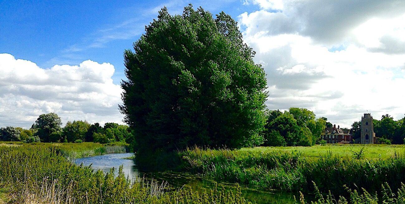
Continue following the tributary for a further 400 yards. You'll pass along the edges of another two fields. Looking back, catch the beautiful view of St James' Church at Hemingford Grey, as shown in the image above.
You'll reach another footbridge, this one over a weir at the beginning of Houghton Trout Stream. Just below the weir there may be an eel in the shallows.
Beyond the footbridge you pass into a wooded area. Here there are two attractions. The first you'll notice are huge wooden trestles as shown below, all that remains of supports that once carried the St Ives to Huntingdon railway over the River Great Ouse.

The second is a babbling brook caused by another smaller weir, a rare sound in the flat lands of Cambridgeshire. As you cross over a second footbridge look back to the weir and you'll see shoals of fish dancing ahead of the weir in oxygen-rich water.
Cross another footbridge and follow along field edges with the Old Mill Stream on your left. Pass through a turnstile and on the left is a wildlife adventure area, a fun place for kids. As you reach Houghton Mill caravan park on your right, to the left you'll find a picnic spot overlooking the mill pond. This spot is very popular, with safe bathing so long as the mill wheel isn't operating.
Point 4
A couple of hundred yards and you reach Houghton Mill cafe, with its idyllic location of picnic tables overlooking the mill pond. The cream tea is delicious, the savoury version not far behind.
Walk on past the cafe to Houghton Mill. This National Trust property, shown below, is worth a visit if open. A mill has been on this site for over 1,000 years. The current building is from the 1600s. Continue the walk by passing the mill and turning right up Mill Street. Glebe Cottage on the left is a beautiful early 1600s timber framed and thatched cottage. St Mary's church dates from the 1300s.

Point 5
At the top of Mill Street you'll reach the village square. Why not have a wander around Houghton village? It's of Anglo Saxon origin, with evidence of settlement as early as Neolithic times. There are many fine listed buildings in the village. The magnificent, but less than perpendicular, timber framed cottage overlooking the square is the village's oldest house, dating from the 15th century. It was originally a yeoman farmer's house, subsequently the George and Dragon public house. The Clock Tower in the centre of the village square is another favourite stopping point to watch peaceful village life pass by.
Turn right by the memorial to Potto Brown and walk down the Thicket road. About 170 yards on the right is Houghton Manor, a very stylish building where the attention to detail is amazing. A few more yards on the left is Rose Cottage, a tiny 1600s thatched cottage. Turn left up the footpath to the side of Rose Cottage to follow yet another hidden and delightful route through the village.
Head roughly straight on for 300 yards, crossing Home Farm Road, until you find yourself back Meadow Lane. Turn left to return to the car park and the start of the walk.
Click the Print Friendly button below to print out this walk to take with you. Or for more walks click the Return Home button at the foot of this page. Did you enjoy the walk? Notice anything unusual? Why not add a comment below to tell fellow amblers what you liked about it?
